by Louise Segreto, Chapter Historian
The Minnesota River is a remarkable river that deserves more attention and respect than it receives. This Spring, I made a concerted effort to get to know her better. What sparked my interest was a chance encounter with a grizzled fisherman that boasted of catching a 50”, 80-pound flathead catfish that he caught in the River near the Bloomington Ferry Bridge. When I teased and challenged him about the size of the alleged fish, he snail mailed me proud photos from his corkboard to prove it.
Standing on the River’s bank looking into the swiftly flowing chocolate colored water, I swirled back in time. The Minnesota River Valley was carved by the torrential glacial River Warren (about 12,000 years ago) at the end of the last ice age. The River Warren flowed from the meltwaters of glaciers that once covered most of northwest Minnesota and southern Canada. When the glaciers melted, they formed ancient Lake Agassiz (700 miles long, 200 miles wide). And when Lake Agassiz overfilled its banks, the River Warren was formed, raging through the Minnesota Valley and scouring out a 5-mile swath. Today the Minnesota River flows as just a narrow ribbon down the wide valley. A great place to view the wide Valley is at the overlook parking lot at Eden Prairie’s Richard T. Anderson Conservation Area. The view there will put this geologic history into perspective and take your breath away.
Fast forward to present. The Minnesota River flows about 370 miles, from its headwaters at the Minnesota/South Dakota border just north of Ortonville and Big Stone Lake to its confluence with the Mississippi River at Ft. Snelling. The landscape of the Minnesota River Valley is naturally vulnerable to erosion. And, being a tributary of the Mississippi, the Minnesota carries and dumps heavy loads of sediment from erosion into the Mississippi and downstream Lake Pepin. Phosphorus from over-fertilized farmlands in the Minnesota Valley fuels excessive algae growth. Herbicide and pesticide contaminants from agricultural runoff flow into the River. Further contributing to the River’s maladies is pollution from contagions and pathogens from failing residential septic systems, and various land uses and commercial development in the watershed. Last but not least, due to climate change, the increased frequency and intensity of rain events make all of the foregoing worse.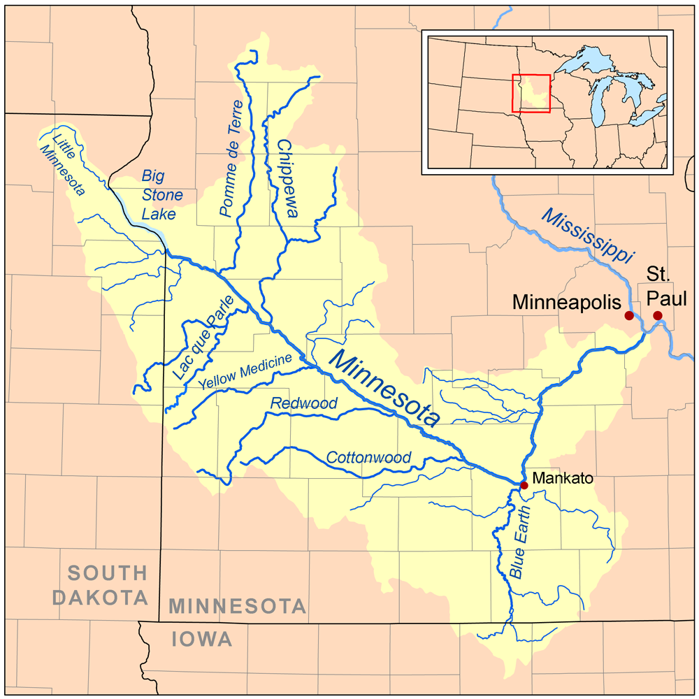
Nevertheless, despite all of its present-day woes, the Minnesota River is a true “Minnesotan”. Geographically it is fully contained within the State of Minnesota. Its huge watershed of approximately 17,000 square miles is responsible for accepting drainage from almost 20% of the total land area of Minnesota. And, despite its impairments, the River continues to sustain strong populations of fish (catfish, sheepshead, northern pike, small mouth bass and bullheads) and is a major migratory flyway for birds. This flyway is even more important to migrating birds in the aftermath of extensive drain tiling of what used to be the expansive prairie pothole lakes region of Minnesota and South Dakota.
Because of the rich soils of the Minnesota River Valley, agricultural interests have always been strong here. Le Sueur is credited with being the birthplace of the canning industry spokesman, the Jolly Green Giant in 1903. During the 1930s the Valley was the USA’s largest producer of sweet corn. Today, the fields are predominately filled with corn and soybeans. Some good news is that more and more farmers are giving careful thought to innovative farming practices that reduce erosion and the need for over fertilizing. And, there is much discussion about how to increase soil health in the Minnesota River Valley and beyond.
What’s up with all the French names? One cannot but notice the number of French place names that abound in the Valley: Le Sueur, Belle Plaine, St. Pierre (St. Peter) and Lac Qui Parle. These French names are a lasting tribute to the importance of early French explorers in the 1600s to this area. Prior to the coming of early European explorers and settlements, the Minnesota River Valley was the home of Native Americans stretching back to very early times. The River Valley supplied fish, game, and water to these early peoples. It is not unusual for archeologists to be called in to examine the contents of burial mounds and pottery artifacts discovered in road and construction projects in the area.
It was along the banks of the Minnesota River just a few miles north of Mankato that the infamous Treaty of Traverse des Sioux was “signed” by Dakota leaders from the Sisseton and Wahpeton tribes ceding nearly 24,000,000 acres of land (including lands ceded under the Treaty of Mendota) west of the Mississippi in 1851 to the US government in exchange for cash, annuities and goods. Sadly, most of these promises were never delivered by the U.S. to the Tribes. Learn more about Minnesota River History by clicking here.
What happens to the direction Minnesota River at Mankato is crazy! It is as if Paul Bunyan had a few too many and decided to put a ninety-degree bend in the River. At Mankato, the south easterly flowing River takes a hard bend to the north east and continues on towards Minneapolis. Spoiler: the underlying bedrock around Mankato is responsible for this phenomenon.
The Minnesota River has several faces, starting at its most northern stretch it is rather straight and steep banked, lined with stately cottonwoods, silver maples, ash and basswood. At Granite Falls the River’s sides are lined with ancient granite gneiss rock outcroppings, over 3.6 billion years old (the Earth is only 4.54 billion years old). And at Redwood Falls to New Ulm, the River becomes passive and windy.
Lately, there has been a lot written about the water quality challenges facing the Minnesota River. Rising nitrate levels are threatening Mankato’s drinking water which is drawn from shallow wells, water quality is continuing to deteriorate, and the Minnesota River is to blame for dumping excessive amounts of silt and sediment downstream into the Mississippi River causing a whole host of problems.
Yet, for better or worse, the Minnesota River flows through Bloomington’s back yard. We must care about it. One non-profit group who does cares a lot is the Friends of the Minnesota Valley whose mission is to protect and enhance the natural resources of the Minnesota Valley River Watershed, including the Minnesota Valley National Wildlife Refuge. According to Ted Suss, President of the Minnesota Valley Chapter of the Izaak Walton League, and someone who is heavily involved in the work of the Friend’s “River Watch” water monitoring program, the Program is “going strong”. The River Watch Program engages high school students to get out and do River water quality monitoring on a long-term consistent basis using Minnesota Pollution Control Agency protocols to build a database that can be used by others working on trying to understand water quality issues and policy. This year, 10 high school teams are sampling River water and 14 teams are committed for next year.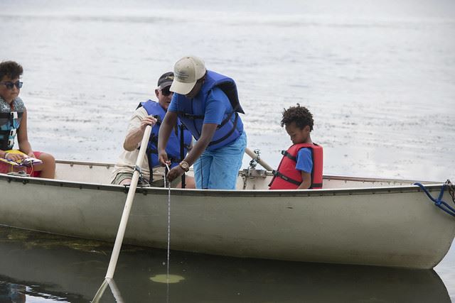
But, too many of us speed over the River in vehicles as we travel along Hwy 169 or 35W and give the River just a passing thought and nod. Others of us may bike, hike, trail run, x-country ski, snow shoe along the trails along the River and may know the Minnesota River more intimately. But, really understanding this River and challenges that it is facing is complex. Take some time to discover the Minnesota River: from its important role in Minnesota history, to its importance to food production, to its subtle natural beauty. Consider supporting the River Watch Program. Stay informed about political issues that affect the River. The Minnesota River needs our help and full attention. As a member of the Izaak Walton League, think about what you can do to rally behind this unsung heroine of a River.
Images courtesy: Wikipedia (map) and Minnesota Pollution Control Agency (water monitoring photo)